California Highway 1 Road Trip: The Ultimate Coastal Drive

There are road trips, and then there is California’s Highway 1. Winding along the Pacific coastline, this iconic highway offers a spectacular combination of dramatic cliffs, turquoise ocean views, charming coastal stops, and breathtaking natural beauty. Every turn seems to reveal another postcard-worthy scene, making it one of the most unforgettable drives in California.
For our journey, we started in Monterey and headed south through Big Sur, continuing toward Morro Bay before ending the day in Ventura. Our itinerary included famous landmarks such as Bixby Bridge and McWay Falls, along with smaller stops that made the drive even more memorable.
Travel Tip
Drive Highway 1 from north to south. This direction generally keeps the ocean and the dramatic cliffside on your right-hand side, making it easier to access many ocean-facing pullouts without crossing oncoming traffic. It also means you can enjoy those sweeping coastal views right beside you as you drive.
Just be warned: the distance on the map doesn’t tell the whole story. You’ll probably stop far more often than you planned! Plan for more way more time than you think you may need.
One important thing to remember: this is not a highway to rush through. Between the winding road, scenic overlooks, and unexpected wildlife sightings, you’ll probably find yourself stopping far more often than you originally planned.

Have extra time? Extend Your California Adventure
Have a little extra time to explore California? Consider adding these destinations to your itinerary! From the vibrant streets of San Francisco to the rugged landscapes of Pinnacles National Park and the spectacular coastal scenery of 17-Mile Drive, these experiences offer even more reasons to extend your California adventure.
San Francisco: Discover the charm of the Golden Gate Bridge, explore historic neighborhoods, ride the iconic cable cars, and enjoy the city’s diverse food scene. This vibrant city is a wonderful addition to any California road trip. [Click here to view more.]
Pinnacles National Park: Venture into a landscape of dramatic rock formations, volcanic spires, and fascinating caves. With scenic hiking trails and opportunities to spot the magnificent California condor, Pinnacles is a rewarding destination for nature and outdoor enthusiasts. [Click here to view more.]
17-Mile Drive: Enjoy one of California’s most picturesque coastal routes through Pebble Beach and Pacific Grove. Admire rugged shorelines, windswept cypress trees, pristine beaches, and the famous Lone Cypress, all set against the beautiful Pacific Ocean. [Click here to view more.]
Channel Islands National Park: Escape to a world of rugged islands, secluded beaches, sea caves, and abundant marine wildlife just off Southern California’s coast. Accessible primarily by boat, these islands offer opportunities for kayaking, snorkeling, hiking, and spotting dolphins, seals, and whales. It’s a wonderful adventure for travelers looking to experience California’s wilder, more untouched side. [Click here to view more.]
Whether you choose to explore a bustling city, hike through a unique national park, or discover another spectacular stretch of coastline, these destinations can make your California road trip even more memorable.
Starting the Day in Monterey
Before beginning our coastal adventure, we spent some time exploring Monterey, a beautiful seaside town known for its maritime history, waterfront scenery, and abundant marine life.

Fisherman’s Wharf and Coast Guard Pier
Our first stop was the waterfront around Fisherman’s Wharf and Coast Guard Pier, where we hoped to catch a glimpse of Monterey’s famous sea lions. The area was lively, with the sound of waves, seabirds circling overhead, and sea lions lounging around the waterfront. Watching these playful animals basking in the sun and occasionally diving into the water was a wonderful way to begin our day.
We were even lucky enough to be fully entertained by a sea otter enjoying a feast.
At Fisherman’s Wharf and Coast Guard Pier, the stars of the show are the California sea lions, known for their playful personalities, expressive faces, and surprisingly photogenic poses. You’ll spot them lounging on floating docks, stretching out in the sun, barking at their neighbors, or balancing their sleek bodies in all sorts of funny positions. Some look like they’re striking a model pose, while others seem completely unbothered by the world around them. If you love wildlife photography, these sea lions offer endless opportunities for candid shots, goofy expressions, and adorable moments that make every photo feel like a little personality portrait!
Cannery Row
Next, we made our way to Cannery Row, one of Monterey’s most recognizable waterfront districts. Once the center of a thriving sardine-canning industry, Cannery Row has transformed into a lively destination filled with shops, restaurants, galleries, and waterfront attractions. Its history is closely associated with writer John Steinbeck, whose novel Cannery Row immortalized the working-class neighborhood and its colorful characters. We enjoyed strolling past the shops and taking in the atmosphere before preparing for the main event: our drive along Highway 1. Little did we know that our carefully planned schedule was about to take an unexpected turn.
Travel Tip
If you’re planning this drive, check for marathon dates, road closures, and other scheduled events before you leave Monterey. A little research can save you hours of waiting or detours.
An Unexpected Delay: The Big Sur Marathon
Of all the days to plan a Highway 1 road trip, we somehow picked the day of the Big Sur International Marathon!
The event takes place along the scenic coastal highway, and portions of the route are closed to vehicle traffic while runners make their way through Big Sur. We ended up waiting around the Monterey area for quite a while as we waited for the road to reopen.
The good news? We eventually got moving. The roads finally opened at 1:30 p.m., and we were on our way toward one of the most beautiful coastal drives in the country.
It wasn’t exactly the early start we’d planned, but sometimes a road trip comes with a little unexpected adventure. If you’re planning this drive, check for marathon dates, road closures, and other scheduled events before you leave Monterey. A little research can save you hours of waiting!
The Drive Begins: Highway 1 Through Big Sur

Once we finally got on the road, the scenery quickly made up for the delay. The Pacific appeared beside us in sweeping shades of blue, waves crashed against rocky coves, and the highway curved along cliffs that seemed to drop straight into the ocean.
This is the stretch where you should resist the urge to rush. Big Sur isn’t a place to simply drive through; it’s a place to experience.
Stop 1: Rocky Creek Bridge

Rocky Creek Bridge is one of the beautiful historic concrete arch bridges along the Big Sur coast. Completed in 1932, the bridge is smaller and often less famous than its better-known neighbor, Bixby Bridge, but it has plenty of coastal charm of its own.
The bridge curves gracefully across a rugged ravine, with the Pacific coastline creating a dramatic backdrop. It’s a wonderful introduction to the engineering and scenery that make Highway 1 so iconic.
Keep an eye out for safe, designated places to pull over nearby. The best views are worth a pause, but the highway has narrow shoulders and fast-moving traffic in places.


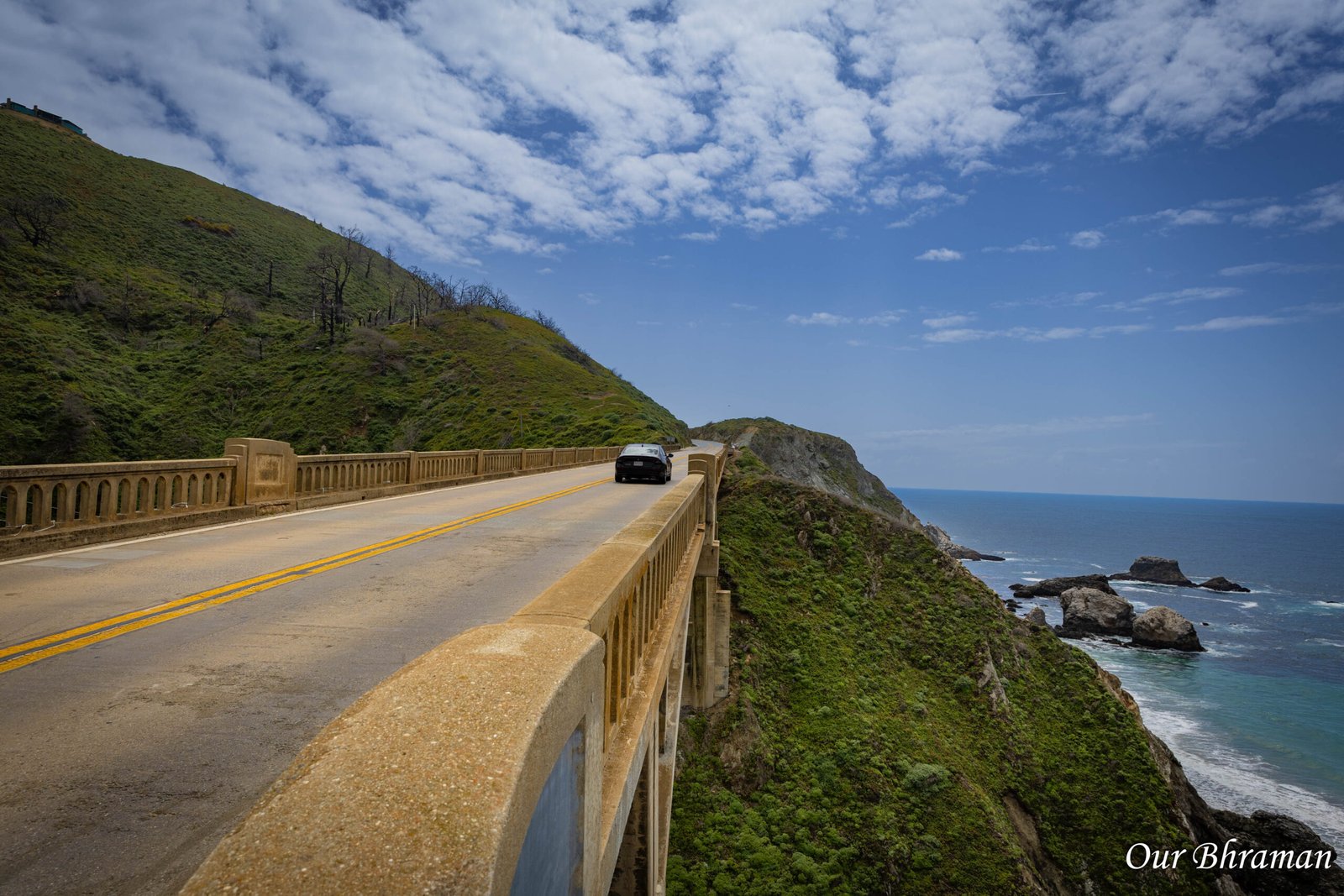
Stop 2: Bixby Creek Bridge

If there’s one landmark that immediately brings California’s Pacific Coast Highway to mind, it’s Bixby Creek Bridge. Completed in 1932, this graceful reinforced-concrete arch bridge spans Bixby Creek Canyon and rises dramatically above the rugged coastline. Its sweeping design, towering cliffs, and ocean backdrop have made it one of the most photographed landmarks along Highway 1. This is a classic Big Sur moment. The bridge seems to emerge straight from the landscape, with the Pacific stretching endlessly into the distance.
Our tip: Don’t settle for the first viewpoint you see. Look for a safe, designated turnout that offers a clear view of the bridge, and be patient if other visitors are taking photos. Never stop in a travel lane or block traffic to get the perfect shot.

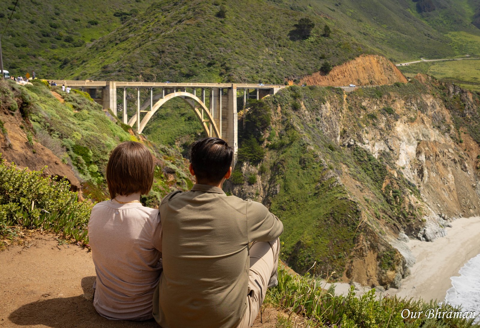

Stop 3: Big Sur Station Visitor Center
After taking in the bridges and coastline, Big Sur Station is a practical stop to work into your itinerary. Located near the entrance to Pfeiffer Big Sur State Park, the station serves as an information point for visitors exploring the Big Sur area. It’s a useful place to ask about nearby parks, trail conditions, and local recreation opportunities. We also used this area for a bathroom break—a reminder that practical stops matter on a long coastal drive! Services can vary, so don’t assume every visitor center or park facility will have restrooms open when you arrive.
If you have extra time, the surrounding area is worth exploring. Big Sur is known for its redwood forests, hiking trails, and landscapes where the mountains meet the sea.
Stop 4: Henry Miller Memorial Library
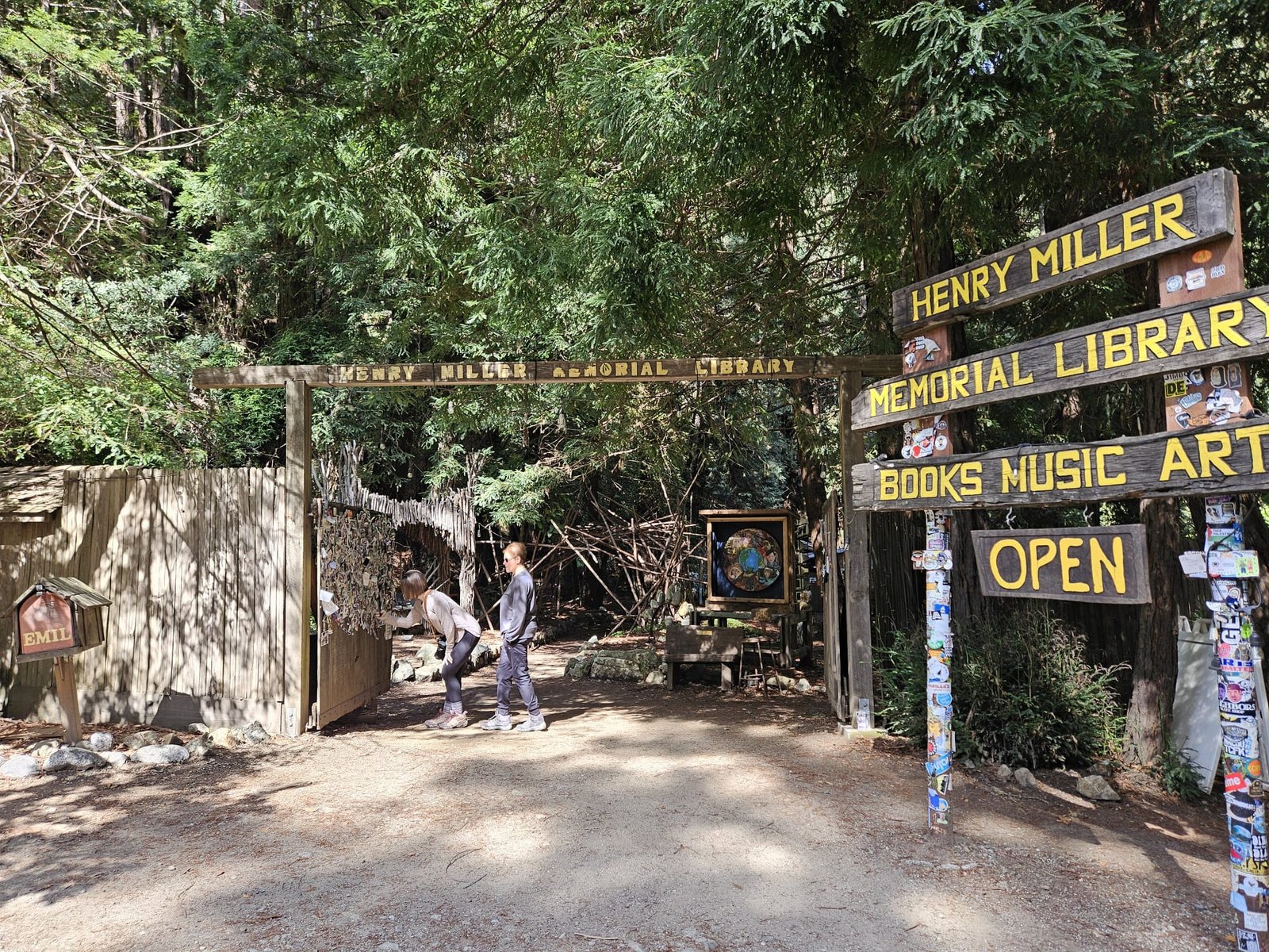
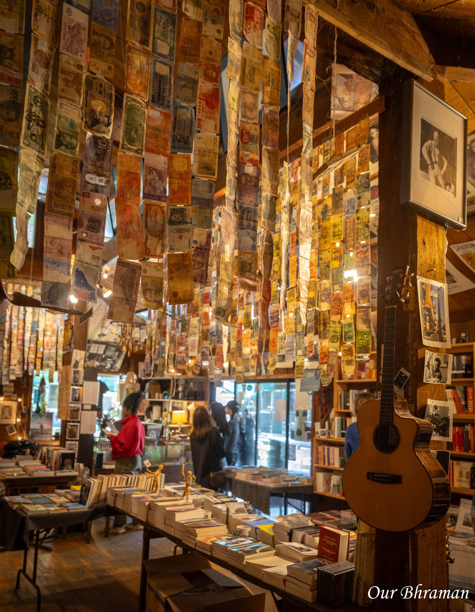
The Henry Miller Memorial Library offers a completely different experience from the sweeping ocean viewpoints. This nonprofit arts center and bookstore celebrates the life and work of Henry Miller, the American writer who lived in Big Sur during the 1940s and 1950s. The library has become a quirky cultural landmark, hosting literary events, art, music, and community gatherings. Surrounded by the Big Sur landscape, it feels like a little creative hideaway tucked into the trees. Browse the books, explore the grounds when open, and enjoy a glimpse of the artistic spirit that has long drawn writers and free thinkers to this part of California.
Check opening hours before visiting, as the library isn’t necessarily open every day or at all times.


Stop 5: McWay Falls

McWay Falls is one of the most recognizable natural sights in Big Sur—and for good reason. This approximately 80-foot waterfall drops from a cliff into a turquoise cove at Julia Pfeiffer Burns State Park. It’s one of California’s rare coastal waterfalls, with a setting that looks almost too beautiful to be real. The falls are especially striking because of the contrast between the white water, golden cliffs, deep-green vegetation, and blue Pacific. It’s the kind of view that makes you stop talking for a moment and simply take it all in.
Important planning note: Access to the McWay Falls Overlook Trail and nearby viewing areas has been affected by storm damage, erosion, and closures. Check current California State Parks alerts before your trip, and follow posted barriers. The waterfall and cove are protected areas, and visitors should not attempt to reach the beach or enter closed areas.
Even if access is restricted during your visit, the surrounding Big Sur coastline is spectacular in its own right.
Stop 6: Ragged Point Inn
As we continued south, Ragged Point Inn made a convenient place to stop, stretch our legs, and take another bathroom break. Often described as the gateway to Big Sur’s southern coastline, Ragged Point sits high above the Pacific and offers sweeping views of rugged cliffs, ocean coves, and the winding highway. The contrast between the dark cliffs and the bright blue water is spectacular, especially when the waves are crashing below.
The property has traditionally offered a restaurant, lodging, and visitor amenities, making it a useful place to pause after several hours of driving and sightseeing. Confirm available services and hours before counting on a meal or restroom stop.
Take a few minutes to enjoy the views before getting back behind the wheel. The coastline continues to deliver one postcard-worthy scene after another as you head south.
Stop 7: Piedras Blancas Elephant Seal Rookery

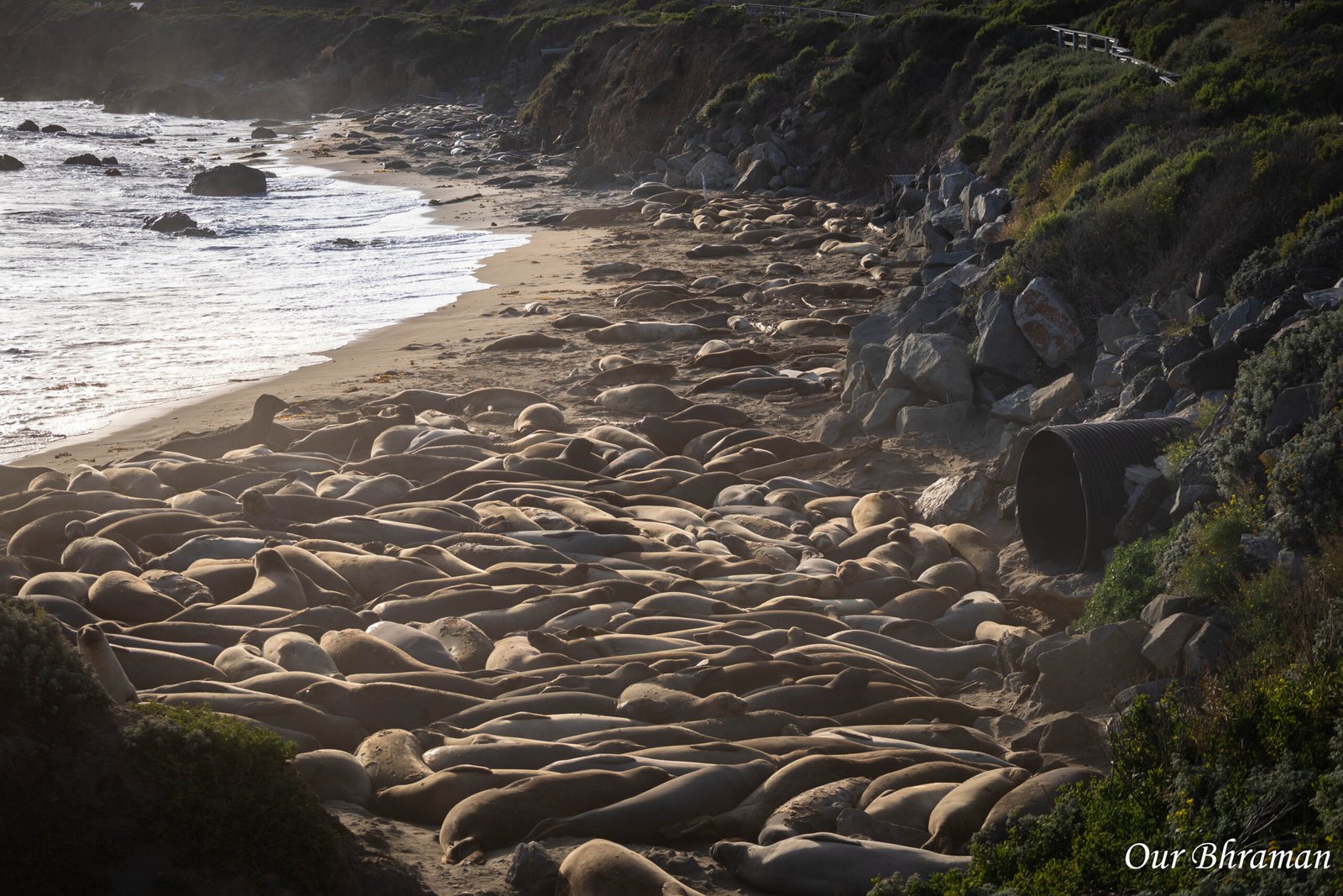
Just north of San Simeon, the Piedras Blancas Elephant Seal Rookery offers a chance to see some seriously impressive wildlife without booking a tour. Northern elephant seals gather along this stretch of coast throughout the year, with different seasons bringing different stages of their life cycle. Depending on when you visit, you may see enormous males, mothers and pups, juveniles, or seals resting on the sand between trips into the ocean. The males are especially memorable, with their massive bodies and distinctive trunk-like noses. Watching them interact, nap, and occasionally make a dramatic display is a reminder that wildlife viewing doesn’t have to involve a hike or a boat ride. The rookery is generally viewed from designated roadside areas and accessible viewing paths. It’s free to visit, although parking and access conditions can vary.
Wildlife etiquette: Keep your distance, stay behind barriers, and never approach or attempt to touch the seals. They may look sleepy and harmless on the beach, but they’re wild animals that need space to rest.
This is a great stop for anyone who loves nature, photography, or simply seeing something you don’t encounter every day.

The Pullouts Are Part of the Adventure
One of the biggest mistakes you can make on a Highway 1 road trip is planning every stop so tightly that you leave no room for surprises. The official landmarks are incredible, but some of the most memorable moments happen between them. You might round a bend and find a secluded-looking cove below the cliffs, spot waves crashing against offshore rocks, see a hawk circling overhead, or discover a viewpoint that makes you want to stay just a little longer.
There are numerous roadside viewpoints and pullouts along the coast, especially through Big Sur. Some offer sweeping panoramas, while others provide close-up views of rugged rock formations, crashing surf, and the winding road itself. Keep your eyes peeled as you drive, but never let the search for scenery distract you from the road. Watch for signed viewpoints, use designated parking areas, and avoid stopping on narrow shoulders or around blind curves. If a turnout is full, keep going—another beautiful view is often just around the bend.
And remember, Highway 1 can take far longer than anticipated. A drive that looks manageable on a map can turn into a full day of exploring once you account for photographs, wildlife stops, bathroom breaks, traffic, roadwork, and the temptation to pull over every few miles. Build flexibility into your schedule. On this road trip, the journey really is the destination.


Final Coastal Stop: Morro Rock in Morro Bay

After miles of cliffs, coves, and open Pacific views, our last major sightseeing stop was Morro Rock in Morro Bay.
Morro Rock is a massive volcanic plug that rises approximately 576 feet above the water at the entrance to Morro Bay Harbor. It’s the defining landmark of this laid-back coastal town, and its unusual shape makes it easy to recognize from miles away. The rock is part of a chain of ancient volcanic formations known as the Nine Sisters, stretching through the San Luis Obispo area. It has also long served as a navigation landmark for mariners. Today, Morro Rock is protected as a state historic landmark and wildlife habitat, particularly for nesting birds. You can enjoy excellent views of the rock from the waterfront, harbor areas, and nearby beach. Climbing Morro Rock is prohibited to protect the sensitive habitat, so plan to admire it from the surrounding public areas instead.
Morro Bay has a relaxed seaside atmosphere that makes it a lovely place to wind down after a full day on the road. Walk along the waterfront, watch the boats in the harbor, look for sea otters, and enjoy the changing colors of the sky as the afternoon fades.
Dinner in Morro Bay
We recommend making Morro Bay your dinner stop before continuing south to Ventura for the night. After a day filled with sightseeing, a relaxed meal near the harbor is a welcome way to slow things down.
The town is known for its seafood and waterfront dining, so it’s a natural place to look for fresh fish, clam chowder, or a casual meal with views of the harbor. If seafood isn’t your thing, you’ll find other dining options around town, too.
Once dinner is finished, it’s time to get back on the road and continue toward Ventura, where you can finally put your feet up after a memorable day exploring California’s coastline.
Keep in mind that Morro Bay to Ventura is still a substantial drive, especially after a day of sightseeing. If you’re following this itinerary, check your arrival time, traffic, and fatigue level before deciding whether to continue that evening.
Planning Your Highway 1 Road Trip
Recommended direction: Monterey to Morro Bay, driving north to south.
Why this direction? Keeping the ocean and cliffside on your right often makes it easier to access ocean-facing pullouts and enjoy the coastal views. Individual turnouts vary, and some stops may require additional maneuvering or a safe turnaround.
Allow a full day: Monterey to Morro Bay is only part of the driving distance, but the scenery, bridges, waterfall viewpoints, wildlife, and spontaneous stops can easily fill the day.
Check road conditions: Highway 1 is vulnerable to landslides, erosion, and storm damage. Big Sur closures can affect the route, and reopening dates can change. Check current Caltrans Highway 1 conditions and California State Parks alerts before setting out.
Plan your fuel and restroom breaks: Services are limited in some stretches of Big Sur. Fill up before leaving Monterey, and use convenient stops when they’re available rather than assuming another will be just around the corner.
Bring layers: Coastal weather can shift quickly. Even when the sun is shining, wind and cool ocean air can make viewpoints chilly.
Start early when possible: We lost part of our day waiting for the Big Sur Marathon road closures to end. Check local event calendars and leave room in your schedule for the unexpected.
Drive safely: Pull over only where permitted, never stop in the roadway for photographs, and watch for cyclists, pedestrians, and wildlife.
One Coastline, Countless Reasons to Stop
California’s Highway 1 is more than a route connecting Monterey to Morro Bay. It’s a collection of moments: sea lions barking at the harbor, bridges suspended above rugged canyons, waterfalls tumbling toward the Pacific, elephant seals resting on the sand, and endless blue ocean views appearing around every bend.
Our day didn’t start exactly as planned, thanks to the Big Sur Marathon, but once the road reopened, the coastline reminded us why this drive deserves a place on every California road-trip itinerary.
So drive south, keep the ocean on your right, leave room for spontaneous stops, and don’t be surprised if your carefully planned itinerary turns into a full day of pulling over just to say, “Okay, one more picture!”
Because on Highway 1, sometimes the best part of the adventure is the view you never planned to stop for.